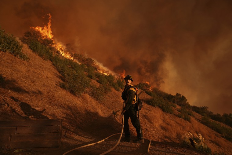
A number of fierce wildfires broke out Tuesday and blazed throughout the Los Angeles area, fueled by strong winds and dry conditions. The fires destroyed hundreds of homes and killed at least 24 people, some of whom perished attempting to stop the fires from engulfing their homes.
Two of the fires were linked to an undetermined number of serious injuries, according to a Los Angeles County fire official, while a city official in Los Angeles called Tuesday night’s fire one of the most horrific and catastrophic she had ever seen in her area of the city.
For live coverage, click this link.
According to climate scientist Daniel Swain, the more information we get, the worse this appears to be.
What we know about the flames is as follows.
Where are the fires?
near Pacific Palisades, a community near Los Angeles east of Malibu, a brush fire broke out Tuesday morning. By Sunday evening, the California Department of Forestry and Fire Protection, or Cal Fire, reported that the fire had spread to over 23,713 acres. Cal Fire reported that the fire was 14% contained and that 5,316 structures were probably damaged or destroyed.
In the enormous national forest lands north of downtown Los Angeles, the Eaton Fire started Tuesday evening close to a canyon. Cal Fire reports that on Monday, it had erupted to 14,117 acres and was 33% contained. According to the organization, the fire most certainly destroyed or seriously damaged about 7,800 buildings.
The Hurst Fire began as a brush fire on Tuesday night in the suburban community of Sylmar, which is located north of San Fernando. Cal Fire reports that as of Saturday night, it had spread to 799 acres and was 95% contained.According to Cal Fire, the fire most certainly destroyed or seriously damaged two buildings.
Other flames erupted in the Los Angeles region on Wednesday and Friday while firefighters battled the biggest blazes. Crews were successful in containing the fires and halting their further progress. According to Cal Fire, the Lidia, Archer, Woodley, Sunset, and Kenneth fires were all completely controlled as of Sunday night and were no longer regarded as active. The fires burned 1,539 acres between them.
How many people are affected?
As crews attempted to contain the fires, nearly 200,000 people were at one time under evacuation orders. The number had dropped to about 92,000 by Monday morning, with an additional 89,000 people in evacuation alert zones.
Unknown numbers of individuals are now homeless as a result of the fires destroying entire blocks and neighborhoods.
Have there been deaths and injuries?
According to Los Angeles County officials, at least 24 individuals have perished in the fires as of Sunday night.
Many of the deaths are still under investigation by the county medical examiner’s office. The government stated that unless the remains are processed at its facilities, it is unable to verify if they are human remains.
According to officials, the Palisades Fire claimed eight lives and the Eaton Fire claimed at least 16.
The identities of those slain may not be confirmed for weeks, according to the medical examiner’s office.
On Thursday, officials cautioned that the death toll could rise as they only started to enter regions for welfare checks and missing person reports.
According to Los Angeles County Fire Chief Anthony Marrone, the Palisades Fire has harmed a sizable number of persons who disregarded evacuation orders. He added that the Eaton Fire has resulted in serious injuries.
How much damage have the fires done?
According to estimates released by JPMorgan on Thursday, the insured losses from last week’s fires may surpass $20 billion, and the total economic losses could amount to $50 billion.
According to Aon data, the losses would significantly outweigh the $12.5 billion in insured damages from the 2018 Camp Fire, which was the most expensive fire in the nation’s history up to that point.
What led to the fires?
The fires’ official cause has not yet been identified.
Strong offshore winds that struck the area Tuesday combined with drought-like conditions—Southern California has had less than 10% of its usual rainfall since October 1—to create fire weather that was, according to the National Weather Service, as terrible as it gets.
A red flag warning was issued by the government to 19 million individuals, signifying a higher risk of fire danger. At many sites throughout the region, wind gusts above 70 mph were observed.
According to Swain, one of the main causes of the fire weather that is engulfing the state is the recent weather whiplash that California has seen, which has seen the state veer between periods of drought and intense rainfall.
According to Inside Climate News, he stated, “It’s not just that drier conditions are perpetually more likely in a warming climate.” The risk of wildfires in Southern California is especially affected by this back-and-forth between states.
When will the fire weather end?
According to the National Weather Service, Santa Ana winds are expected to persist through Wednesday in areas of Ventura and Los Angeles counties, with the possibly destructive gusts occurring between early Tuesday and Wednesday morning.
According to the weather service, severe fire conditions are still present even if the winds are not predicted to be as powerful and destructive as those that caused the two worst fires to start and spread last week.
Much of Ventura and Los Angeles counties are under a red flag warning through Wednesday.
