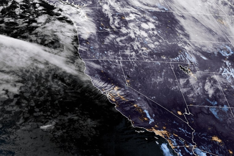
On Tuesday night, a strong atmospheric river is predicted to hit the Pacific Northwest and northern California, bringing with it strong winds, up to 15 inches of precipitation, and a lot of snow in the mountains.
Wind gusts of 60 to 70 mph are predicted for the northern California, Oregon, and Washington coastlines, according to the National Weather Service. Gusts might reach hurricane force in some places.
“We’re expecting the impacts to begin along the coast this afternoon and really peak this evening,” stated Connie Clarstrom, a meteorologist with the National Weather Service in Medford, Oregon. “We are expecting near hurricane force winds near the coast with hurricane force wind gusts over the capes and headlands.”
Parts of the Cascade mountains, which run down the West Coast’s spine, might experience a whiteout blizzard, according to forecasters. Mount Shasta City in northern California may receive up to two feet of snow as a result of the storm. The city’s proximity to Interstate 5 may generate traffic jams.
In the meantime, gusts of wind might reach 90 mph at the 14,411-foot top of Mount Rainier in the state of Washington.
The so-called bomb cyclone, also known as bombogenesis, which occurs when a storm system quickly strengthens as air pressure decreases, is what is causing the intense winds. When a storm’s pressure decreases by 24 millibars in a 24-hour period, it is considered a bomb cyclone.
The Center for Western Weather and Water Extremes director, Marty Ralph, stated that this one was expected to deepen, more like 60 millibars in a day, which is extremely rare and obscenely quick. It’s very intense.
An atmospheric river, a lengthy plume of moisture from the tropical Pacific, will be brought in by the bomb cyclone.
According to a 2022 study, atmospheric rivers can be the main sources of precipitation on the West Coast each year and, on average, generate more than $1.1 billion in flood damage annually.According to study, atmospheric rivers are responsible for about 84% of flood damage in Western states.
Scientists believe atmospheric rivers are being impacted by climate change. Storms can produce more severe precipitation when the atmosphere is warmer because it can absorb more water vapor.
“The warmer the air is, the more water vapor it can hold, and that’s more potential energy,” Ralph explained.
Nine atmospheric river storms pounded California during three weeks in late 2022 and early 2023, causing extensive flooding, landslides, downed trees, and wind damage.Moody’s RMS estimated that the series of storms caused between $5 billion and $7 billion in total economic losses in the United States.
This storm will probably bring most of the moisture to northern California.
“Strong and stalling is its primary characteristic. Over the course of three days, those two factors can result in 10 to 20 inches of rain,” Ralph stated.
From Tuesday morning until Saturday, flood watches were in effect for Shasta County, western Colusa County, and the northern and central Sacramento Valley.
In just two to three days, the Russian River is expected to get almost 10 inches of precipitation, or 20% of its yearly average, according to Ralph. Along the river, some moderate flooding is anticipated.
The National Water Prediction Service has warned that minor to major flooding may occur in a number of additional northern California rivers, including the Eel River.
Flooding is less likely to occur in the larger rivers. The terrain is comparatively dry, and the season is still early,” Ralph stated. “We’re a little bit fortunate.”
In California and other western states, atmospheric rivers are crucial for increasing water supplies, even if they can cause havoc in the fall and winter. The storm will start to restore groundwater that has been drained during a hot summer by filling reservoirs.
“Feast and famine are the stories of California water and the West in general. “There are risks and advantages to large storms,” Ralph stated.
Based on their anticipated duration and the maximum volume of water vapor they carry, Ralph and other researchers developed a 1–5 scale to rank atmospheric rivers that hit the West Coast. The storm is predicted to be an AR 4 in most places in northern California.
Note: Thank you for visiting our website! We strive to keep you informed with the latest updates based on expected timelines, although please note that we are not affiliated with any official bodies. Our team is committed to ensuring accuracy and transparency in our reporting, verifying all information before publication. We aim to bring you reliable news, and if you have any questions or concerns about our content, feel free to reach out to us via email. We appreciate your trust and support!
