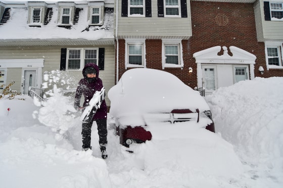
As millions of Americans return home from their Thanksgiving trips, an Arctic blast has brought snow, frost, and dangerously cold winds to the northern Plains, Midwest, and Great Lakes, making travel extremely difficult to impossible on one of the busiest days of the year.
Winter alerts are in effect for over 7 million people in Wisconsin, Michigan, Ohio, Pennsylvania, and New York, and some of them are predicted to stay in effect until Tuesday morning.
Travel-delaying lake effect snow bands and showers have formed downwind of the Great Lakes in northeast Ohio, far northwest Pennsylvania, western New York, and parts of northwest New York, according to a National Weather Service advisory issued on Sunday.
On Friday, New York Governor Kathy Hochul proclaimed a state of emergency in several counties, including Allegany, Oswego, and Erie. According to Hochul’s administration, people in western and northern New York can anticipate 1 to 4 inches of lake effect snow every hour until Monday.
Hochul cautioned New Yorkers against needless travel. In order to assist local communities, over 100 National Guard personnel were stationed in western New York, she stated in a statement.
After being blocked on Friday, Interstate 90 in western New York was reopened to passenger traffic Saturday afternoon, Hochul said, adding that commercial trucks were remained prohibited from traveling in both directions along the westernmost section of the interstate beginning at Exit 46. Western New York could see another 1 to 2 feet of snowfall, with Chautauqua and south-central Erie counties likely to see the largest accumulations.
According to the NWS, the greatest snow accumulations are anticipated east of Lake Ontario, where by early next week, isolated locations around the Watertown, New York, area may receive up to 60 inches of lake effect snow. An additional 1 to 3 feet of snow is predicted to fall on the Tug Hill Plateau through Tuesday morning, making it particularly heavily impacted.
Before Tuesday morning, Orchard Park could get anywhere from 8 to 20 inches of snow in the Buffalo Niagara Falls Metropolitan area. In the Southtowns of Buffalo, bands of lake effect snow will be active overnight, with up to two feet of snow and extremely dangerous traffic possible, according to the weather service office in Cheektowaga, New York, which covers Buffalo, on Saturday.
According to Hochul’s office, lake effect snow is expected to start to affect central New York and portions of the Mohawk Valley region on Sunday and Monday. The Mohawk Valley region may receive up to 5 inches of snow, while central New York may receive up to 10 inches.
According to the agency, Erie, Pennsylvania, has received 30 inches of snow, the most so far. By Tuesday, up to six feet of snow could cover the ground in northern Pennsylvania’s Erie County, according to federal forecasters. In the city, another 10 to 20 inches of snow is anticipated.
Travel between Cleveland and Buffalo may be impacted by more than a foot of lake effect snow in some areas of the region beginning at noon on Sunday and lasting until 7 a.m. on Tuesday, according to the Cleveland weather service office on Saturday.
Through Monday, places like Traverse City, Marquette and Ironwood in Michigan, and Milwaukee in Wisconsin could see an additional 2 to 10 inches of snow.
Winter alerts are still in effect for parts of eastern Kentucky and West Virginia. The meteorological service reports that sporadic snow showers will continue on Sunday morning. These warnings remain in effect through the afternoon for Charleston and Jackson, Kentucky, with an additional 1 to 2 inches of snow expected.
About 2 million people are under a freeze alert through Sunday night for areas of north Florida and southeast Georgia, including Lake City and Gainesville, where nightly lows are expected to drop into the upper 20s and low 30s.
Sunday afternoon temperatures will continue to be 10 to 20 degrees below normal from the Northern Plains through the Midwest and East Coast. The Midwest will remain in the 20s and 30s, while the Dakotas will have single-digit highs. Highs in the Northeast and Mid-Atlantic will be in the 30s and 40s.
Throughout the coming week, temperatures in the central and eastern United States will typically remain at or below freezing.
The Transportation Security Administration predicted earlier in November that Sunday would rank among the top three travel days of the year.
3.6 million people were under lake effect snow warnings, 4.5 million were under freeze warnings, 8.5 million were under winter weather advisories, and 1 million were under frost advisories on Saturday, out of the more than 17 million people under National Weather Service winter alerts.
A cold air mass moving south from Canada and beyond over the relatively warm Great Lakes swiftly draws part of the lake water into the atmosphere, creating fertile clouds and producing 2 to 3 inches or more of snow each hour, according to the weather service.
Although its impacts should subside by the beginning of next week, meteorologists cautioned that an Arctic air mass was still moving south from Canada and that colder air was still on its way south.
Note: Every piece of content is rigorously reviewed by our team of experienced writers and editors to ensure its accuracy. Our writers use credible sources and adhere to strict fact-checking protocols to verify all claims and data before publication. If an error is identified, we promptly correct it and strive for transparency in all updates, feel free to reach out to us via email. We appreciate your trust and support!
