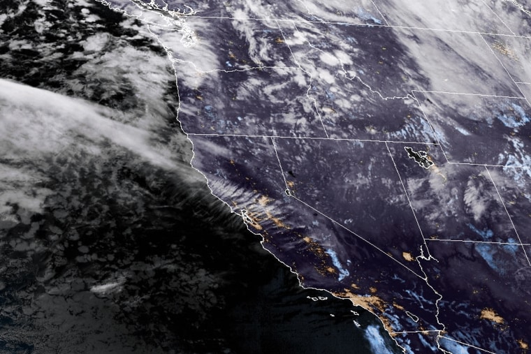
As Northern California and the Pacific Northwest began to experience the effects of a strong atmospheric river event, officials reported that a woman was killed by a fallen tree and that tens of thousands of residences in Washington state lost power on Tuesday.
According to experts, the storm may deliver significant snowfall in the mountains and up to 15 inches of rain. According to the tracking website poweroutage.us, by approximately 7 p.m. local time, nearly 100,000 households and businesses in Washington and over 14,000 in Oregon were without power.
Around 8 p.m. on Tuesday, the Bellevue, Washington, fire department posted on Xat that “trees are falling on houses and all over the city.” Go to the lowest floor and avoid windows if at all possible. If at all possible, stay indoors.
Around 7 p.m., a tree fell on an encampment near Lynnwood, Snohomish County, Washington, killing a woman in her 50s, according to South County Fire.
The Cascade mountains, which run down the West Coast’s spine, might be pounded by a whiteout blizzard, according to forecasters. Mount Shasta City in Northern California may receive up to two feet of snow as a result of the storm. The city’s proximity to Interstate 5 may generate traffic jams.
In the meantime, gusts of wind might reach 90 mph at the 14,411-foot top of Mount Rainier in the state of Washington. According to the meteorological service, a 52 mph gust was recorded Tuesday night at Seattle Tacoma International Airport.
According to Connie Clarstrom, a meteorologist with the National Weather Service in Medford, Oregon, we anticipate hurricane-force wind gusts over the capes and headlands and near-hurricane-force winds close to the shore.
The so-called bomb cyclone, also known as bombogenesis, which occurs when a storm system quickly strengthens as air pressure decreases, is what is causing the intense winds. When a storm’s pressure decreases by 24 millibars in a 24-hour period, it is considered a bomb cyclone.
The Center for Western Weather and Water Extremes director, Marty Ralph, stated that this one was expected to deepen, more like 60 millibars in a day, which is extremely rare and obscenely quick. It’s very intense.
An atmospheric river, a lengthy plume of moisture from the tropical Pacific, will be brought in by the bomb cyclone.
According to a 2022 study, atmospheric rivers can be the main sources of precipitation on the West Coast each year and, on average, generate more than $1.1 billion in flood damage annually.According to study, atmospheric rivers are responsible for about 84% of flood damage in Western states.
Scientists believe atmospheric rivers are being impacted by climate change. Storms can produce more severe precipitation when the atmosphere is warmer because it can absorb more water vapor.
“The warmer the air is, the more water vapor it can hold, and that’s more potential energy,” Ralph explained.
Nine atmospheric river storms pounded California during three weeks in late 2022 and early 2023, causing extensive flooding, landslides, downed trees, and wind damage.Moody’s RMS projected that the series of storms caused $5 billion to $7 billion in total economic losses in the United States.
This storm will probably bring most of the moisture to northern California.
“Strong and stalling is its primary characteristic. Over the course of three days, those two factors can result in 10 to 20 inches of rain,” Ralph stated.
From Tuesday morning through Saturday, flood watches have been in effect for Shasta County, western Colusa County, and the northern and central Sacramento Valley.
According to Ralph, in just two or three days, the Russian River might get almost 10 inches of precipitation, or 20% of its yearly average. Along the river, some moderate flooding is anticipated.
Several other rivers in Northern California, including the Eel River, could see minor and moderate flooding,according to the National Water Prediction Service.
The bigger rivers are less likely to flood. It s still early in the season and the landscape is relatively dry,” Ralph said. “We’re a little bit fortunate.”
Daniel Swain, a climate scientist at UCLA, said there was a 10% to 20% chance that some areas north of Santa Rosa, California, and into southern Oregon would receive record three-day rainfall as a result of the storm.
In some places, it will more or less rain continuously from about right now through Sunday morning at least, Swain said in a Tuesday afternoon briefing. This looks like a more extreme rain event than it will be a flood event.
While atmospheric rivers can bring chaos in fall and winter, they’re important for boosting the water supplies in California and other western states. The storm will fill reservoirs and begin to replenish groundwater depleted during a hot summer.
“That s the story of California water, and the west in general, feast and famine. Big storms come both as hazards and benefits,” Ralph said.
Ralph and other researchers built a 1-5 scale to rate atmospheric rivers striking the West Coast, based on their expected duration and the peak amount of water vapor they transport. In Northern California, the storm isexpected to rate as an AR 4 in most locations.
Note: Thank you for visiting our website! We strive to keep you informed with the latest updates based on expected timelines, although please note that we are not affiliated with any official bodies. Our team is committed to ensuring accuracy and transparency in our reporting, verifying all information before publication. We aim to bring you reliable news, and if you have any questions or concerns about our content, feel free to reach out to us via email. We appreciate your trust and support!
